SMOKY MOUNTAIN LOOP HISTORY
Smoky Mountains - US 441
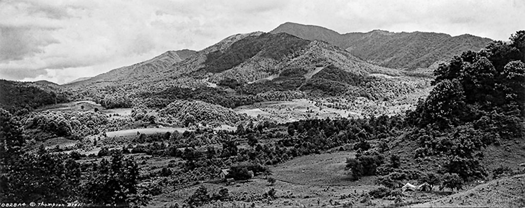
The Smoky Mountains is a range of mountains part of the Appalachians. It straddles the border between North Carolina and Tennessee. Some 14,000 years ago it was inhabited by Native Indians who constructed villages on each side and traveled on rugged foot paths that had been made centuries before by wild animals using paths of least resistance through the mountains.
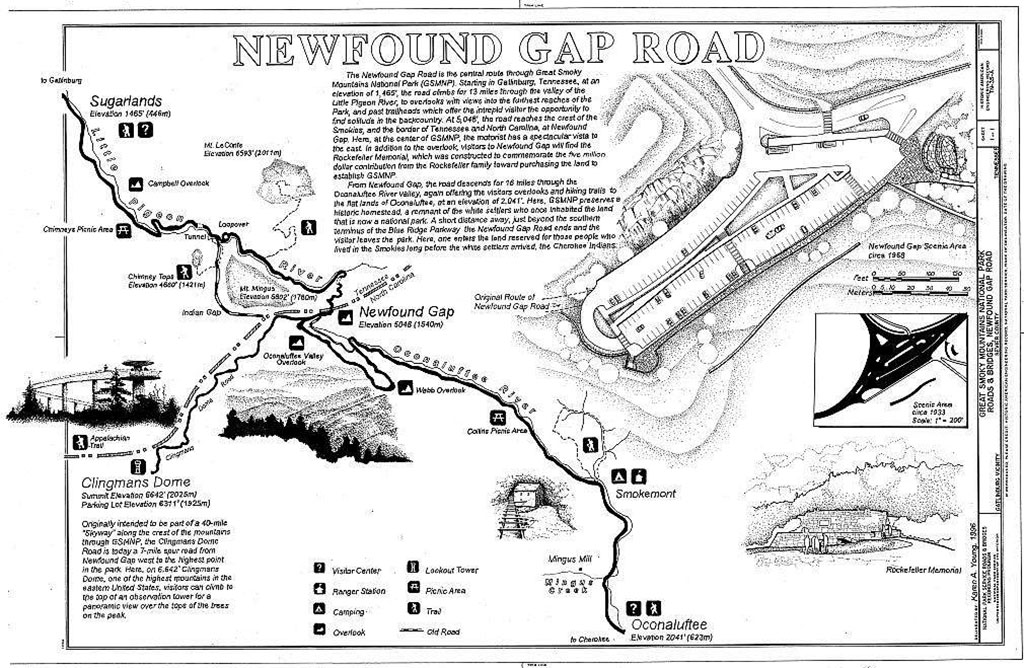
The main route followed what was called the Indian Gap Trail from what is now Gatlinburg to the summit at Indian Gap at 5,390 feet elevation and then winding down to present day Cherokee. Today's US 441 parallels this early trail passing through nearby New Found Gap at 5, 087 feet.
The Indians were the only inhabitants of this area until several early explorers in the mid-1500s. It wasn't until the mid-1700s that European explorers and settlers began arriving in numbers. By the early 1800s settlers arrived on either side of the still wild mountain range. Travel on the narrow foot paths was limited for the most part to foot traffic and horses.
As more settlers moved in the footpaths were improved to allow wagons to pass, but these early roads were poorly maintained and dangerous in many places.
By the time of the Civil War both Union and Confederate soldiers roamed the area. Also present were the "bushwackers" who claimed fealty to both sides whichever was convenient at the time. These highwaymen in reality only cared about what they could steal, killing anyone in their way.
The first logging operations in the Smokies began in the 1880s as resources from easier accessed forests became exhausted. Early loggers used the rivers to transport logs to nearby mills. By the early 1900s new technology saw railroads taking over the transport.
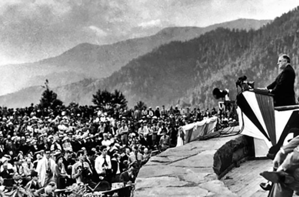
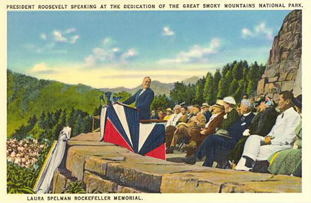
In the period of 1909 to 1920 several entrepreneurs from Knoxville began efforts to bring tourism to the western slopes along the Little River and the idea of creating a National Park first surfaced. Land purchases were nearly completed in 1932 and the Great Smoky Mountain National Park was dedicated by President Franklin Roosevelt in 1934 at Newfound Gap.
By this time a crude roadway had been completed from Gatlinburg to Newfound Gap. The section descending to Cherokee was still under construction.
Today US 441, the main route through the Smokies, is a modern highway. The Great Smoky Mountain National Park is the most visited National Park in the United States.
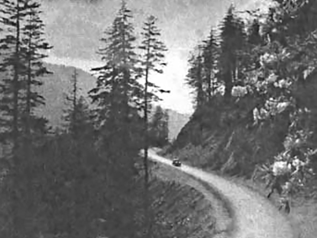
TN 73 - Little River Road
This scenic highway for the most part follows Little River as it slices its way through rock cliffs on either side of the roadway. The area was first explored and opened-up by logging companies in the 1880s. Over time these companies graded and laid railroad tracks along the river.
By the early 1900s several people looked to the area as a tourist attraction. Crude roads were built over the existing railroad beds after the loggers had been bought-out. By the 1930s the area had been included in the Great Smoky Mountains National Park project.
Today TN 73 is a great touring road, although sometimes crowded. It was listed as one of the ten most scenic roads in America by Readers Digest.
Foothills Parkway
The Foothills Parkway has been in the works for some 75 years and is probably another 20 years to completion. The southernmost 17 miles running from US 129 at the Chilhowee Lake to US 321 at Walland was completed in 1966 and is quite spectacular. The next phase of 16 miles was opened in December of 2018. This extension runs 17-miles from US 321 in Walland to Wear's Valley.
There is a northern 5.6 miles open from I-40 south to US 321 near Cosby. This short section was opened in 1968.
Meanwhile, in between these sections is 33.5 miles where construction has not even begun. Right-of-way has been purchased by the National Park Service, but funding is not in place.
Portions of the Parkway skirts the Great Smoky Mountains National Park, the most visited National Park in the United States. This has discouraged the Parkway construction by some and encouraged it by others. The Parkway offers tourists another scenic route that will ease some traffic.
The southern section of the Parkway offers some spectacular views of the Great Smoky Mountains on one side and the Tennessee Valley on the other. On clear days one can see all the way to the Cumberland Mountains 50 miles to the west.
Tail of the Dragon
The Dragon has a notorious past. Much of the route was originally just an animal track worn down by large herds of buffalo and then used by native American Cherokee Indians for centuries. The first white men to use the trail were hunters and trappers moving into dangerous territory in the early 1700s. In 1756 British soldiers struggled through the mountain gaps to establish Fort Louden, one of the first outposts west of the Appalachian mountains. The fort was attacked by Indians in 1760 forcing the few surviving soldiers to retreat.
At some point there was a small outpost/store located near the North Carolina/Tennessee State Line. The Deal family owned and operated it, hence the map designation of Deals Gap. The family later moved west to a more hospitable location.
In the early 1800s the path became a crude roadway used to access the extremely remote settlement of Cades Cove via the Parsons Branch Road. Today this 8-mile gravel road still exhibits some of the excitement of the early days with 19 water fords. But note that the Parsons Branch Road is “one-way” out of Cades Cove to the Dragon. This route suffered severe damage in the floods of 2002 and was closed several years for repairs. As of 2020 the road is closed once again due to the danger of dead falling trees.
There were many conflicts between the Cherokee and white settlers who infringed upon their world. Both sides took lives in needless disputes and petty quarrels. This undeclared warfare resulted in one of the saddest events in our early American history – the Trail of Tears relocation of the Cherokee to Oklahoma. Many Native Americans refused to assemble and leave the only land they had ever known. The Dragon was one of the remote paths they used to evade the Army sent to capture them.
The Civil War brought more bloodshed to the Dragon and surrounding areas. There is a grave-site located at mile 6.5 of the Dragon giving testimony to the times. It is where Bas Shaw was buried after being killed by Confederates as he was transported to prison in Asheville. There are likely many more buried in the nearby mountains in unmarked graves.
Gangs, such as the Kirkland Bushwhackers, often attacked Northern patrols and anyone else who happened their way. They killed two of Bas Shaw's sons nearby. The forested mountains offered the perfect hiding place to escape detection. And the law was reluctant to venture after them.
As more settlers moved into the area landowners began collecting tolls for use of the road. Toll Booth Corner, located at mile 3.0, was a place to pay for the right to cross private property. There were corrals to keep the livestock in transit and meager sleeping quarters for guests to spend the night. Some who tried to cross without paying the toll were caught and supposedly hanged on the spot.
Circa 1913 a town was actually born on the Dragon. Calderwood, formerly the Howard farm property, was created as living quarters for employees constructing Cheoah Dam in 1917, Calderwood Dam in 1930, and those workers who later maintained the entire system. A railway ran from Knoxville, through Calderwood, and followed the Little Tennessee River all the way to Tapoco in North Carolina. Equipment, supplies and workers were transported on this line. Calderwood was also used by Alcoa Aluminum, aka Tapoco, Inc. as a corporate retreat for their executives. There was even a golf course accessed by ferry across the Little Tennessee River. Today’s Tapoco Lodge was also built by Alcoa for their executives. The entire dam and reservoir system provided electric power to Alcoa’s large aluminum processing plant north of Maryville, Tennessee.
The Dragon in the late 1920s was designated as TN72 on the Tennessee side and NC288 on the North Carolina side (today’s NC28 to Fontana). Completion of the bridge near Tapoco in 1931 allowed connection of NC108 to NC288. In 1934 NC 108 and TN72 was renumbered as US129 and was most likely paved for the first time around that date.
The new road was only lightly traveled for decades, primarily by locals, hunters and lost tourists. The small motel and diner went through many different owners from the 50s to the 90s. It was owned by the Moodys, the Craftons, and was known after that as Macs Motel and later The Crossroads of Time. Today it is Deals Gap Motorcycle Resort.
Moonshiner 28
Originally designated as NC 288, portions of this early 1900s roadway which paralleled the Little Tennessee River in North Carolina is currently under Fontana Lake. Parts of the old NC 288 not underwater are in the Great Smoky Mountains National Park and are no longer accessible.
By the 1930s the road had been redesignated as NC 28 and was little more than a poorly maintained cart path from Deals Gap to Fontana. With the completion of Fontana Dam in the 1940s the roadway was improved and paved. Many gallons of local moonshine have been smuggled down this remote mountain highway which now stretches from Deals Gap, North Carolina to Walhalla, South Carolina.
ate 2017.